 United States Minor Outlying Islands
|
| Basic Facts |
| Country name |
conventional long form: none
conventional short form: Baker Island; Howland Island; Jarvis Island; Johnston Atoll; Kingman Reef; Midway Islands; Palmyra Atoll |
| Gevernment type | Islamic republic |
| Capital |
name: Kabul
geographic coordinates: 34 31 N, 69 12 E time difference: UTC+4.5 (9.5 hours ahead of Washington, DC during Standard Time) |
| Flag description | the flag of the US is used |
| Currency | afghani (AFA) |
| Internet country code | .af |
| Ports and terminals |
Baker, Howland, and Jarvis Islands, and Kingman Reef: none; offshore anchorage only
Johnston Atoll: Johnston Island Midway Islands: Sand Island Palmyra Atoll: West Lagoon |
| Agriculture products | opium, wheat, fruits, nuts; wool, mutton, sheepskins, lambskins |
| Industries | small-scale production of textiles, soap, furniture, shoes, fertilizer, cement; handwoven carpets; natural gas, coal, copper |
| Geography |
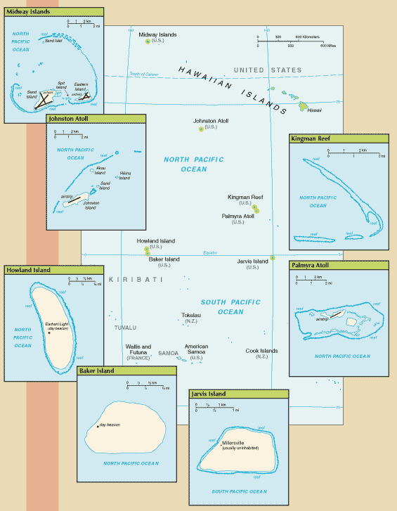
| Location | Oceania
Baker Island: atoll in the North Pacific Ocean 1,830 nm (3,389 km) southwest of Honolulu, about half way between Hawaii and Australia Howland Island: island in the North Pacific Ocean 1,815 nm (3,361 km) southwest of Honolulu, about half way between Hawaii and Australia Jarvis Island: island in the South Pacific Ocean 1,305 nm (2,417 km) south of Honolulu, about half way between Hawaii and the Cook Islands Johnston Atoll: atoll in the North Pacific Ocean 717 nm (1,328 km) southwest of Honolulu, about one-third of the way from Hawaii to the Marshall Islands Kingman Reef: reef in the North Pacific Ocean 930 nm (1,722 km) south of Honolulu, about half way between Hawaii and American Samoa Midway Islands: atoll in the North Pacific Ocean 1,260 nm (2,334 km) northwest of Honolulu near the end of the Hawaiian Archipelago, about one-third of the way from Honolulu to Tokyo Palmyra Atoll: atoll in the North Pacific Ocean 960 nm (1,778 km) south of Honolulu, about half way between Hawaii and American Samoa |
| Coordinates |
Baker Island: 0 13 N, 176 28 W
Howland Island: 0 48 N, 176 38 W Jarvis Island: 0 23 S, 160 01 W Johnston Atoll: 16 45 N, 169 31 W Kingman Reef: 6 23 N, 162 25 W Midway Islands: 28 12 N, 177 22 W Palmyra Atoll: 5 53 N, 162 05 W |
| Continent | Oceania |
| Area | total - 6,959.41 sq km; emergent land - 22.41 sq km; submerged - 6,937 sq km
Baker Island: total - 129 sq km; emergent land - 2.1 sq km; submerged - 127 sq km Howland Island: total - 139 sq km; emergent land - 2.6 sq km; submerged - 136 sq km Jarvis Island: total - 152 sq km; emergent land - 5 sq km; submerged - 147 sq km Johnston Atoll: total - 276.6 sq km; emergent land - 2.6 sq km; submerged - 274 sq km Kingman Reef: total - 1,958.01 sq km; emergent land - 0.01 sq km; submerged - 1,958 sq km Midway Islands: total - 2,355.2 sq km; emergent land - 6.2 sq km; submerged - 2,349 sq km Palmyra Atoll: total - 1,949.9 sq km; emergent land - 3.9 sq km; submerged - 1,946 sq km |
| Boundaries | none |
| Coastline |
Baker Island: 4.8 km
Howland Island: 6.4 km Jarvis Island: 8 km Johnston Atoll: 34 km Kingman Reef: 3 km Midway Islands: 15 km Palmyra Atoll: 14.5 km |
| Climate |
Baker, Howland, and Jarvis Islands: equatorial; scant rainfall, constant wind, burning sun
Johnston Atoll and Kingman Reef: tropical, but generally dry; consistent northeast trade winds with little seasonal temperature variation Midway Islands: subtropical with cool, moist winters (December to February) and warm, dry summers (May to October); moderated by prevailing easterly winds; most of the 1,067 mm (42 in) of annual rainfall occurs during the winter Palmyra Atoll: equatorial, hot; located within the low pressure area of the Intertropical Convergence Zone (ITCZ) where the northeast and southeast trade winds meet, it is extremely wet with between 4,000-5,000 mm (160-200 in) of rainfall each year |
| Terrain | low and nearly level sandy coral islands with narrow fringing reefs that have developed at the top of submerged volcanic mountains, which in most cases rise steeply from the ocean floor |
| Natural resources | terrestrial and aquatic wildlife |
| Natural hazards |
Baker, Howland, and Jarvis Islands: the narrow fringing reef surrounding the island can be a maritime hazard
Kingman Reef: wet or awash most of the time, maximum elevation of less than 1 m makes Kingman Reef a maritime hazard Midway Islands, Johnston, and Palmyra Atolls: NA |
| People |
| Population | no indigenous inhabitants
note: public entry is by special-use permit from US Fish and Wildlife Service only and generally restricted to scientists and educators; visited annually by US Fish and Wildlife Service Johnston Atoll: in previous years, an average of 1,100 US military and civilian contractor personnel were present; as of May 2005 all US government personnel had left the island Midway Islands: approximately 40 people make up the staff of US Fish and Wildlife Service and their services contractor living at the atoll Palmyra Atoll: four to 20 Nature Conservancy and US Fish and Wildlife staff |
| Ethnic groups | Pashtun 42%, Tajik 27%, Hazara 9%, Uzbek 9%, Aimak 4%, Turkmen 3%, Baloch 2%, other 4% |
| Religions | Sunni Muslim 80%, Shi'a Muslim 19%, other 1% |
| Languages | Afghan Persian or Dari (official) 50%, Pashtu (official) 35%, Turkic languages (primarily Uzbek and Turkmen) 11%, 30 minor languages (primarily Balochi and Pashai) 4%, much bilingualism |
