| Country name |
conventional long form: Pitcairn, Henderson, Ducie, and Oeno Islands
conventional short form: Pitcairn Islands |
| Gevernment type | NA |
| Capital |
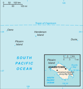
name: Adamstown
geographic coordinates: 25 04 S, 130 05 W
time difference: UTC-9 (4 hours behind Washington, DC during Standard Time) |
| Flag description | blue with the flag of the UK in the upper hoist-side quadrant and the Pitcairn Islander coat of arms centered on the outer half of the flag; the coat of arms is yellow, green, and light blue with a shield featuring a yellow anchor |
| Currency | New Zealand dollar (NZD) |
| Internet country code | .pn |
| Ports and terminals | Adamstown (on Bounty Bay) |
| Agriculture products | honey; wide variety of fruits and vegetables; goats, chickens |
| Industries | postage stamps, handicrafts, beekeeping, honey |
| Location | Oceania, islands in the South Pacific Ocean, about midway between Peru and New Zealand |
| Coordinates | 25 04 S, 130 06 W |
| Continent | Oceania |
| Area |
total: 47 sq km
land: 47 sq km
water: 0 sq km |
| Boundaries | 0 km |
| Coastline | 51 km |
| Climate | tropical; hot and humid; modified by southeast trade winds; rainy season (November to March) |
| Terrain | rugged volcanic formation; rocky coastline with cliffs |
| Natural resources | miro trees (used for handicrafts), fish
note: manganese, iron, copper, gold, silver, and zinc have been discovered offshore |
| Natural hazards | typhoons (especially November to March) |
 Pitcairn