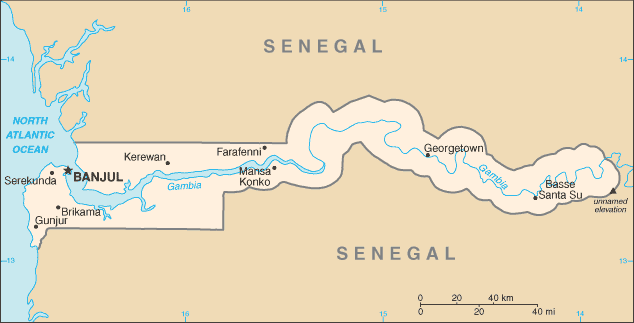
| Country name |
conventional long form: Republic of The Gambia
conventional short form: The Gambia |
| Gevernment type | republic |
| Capital |
name: Banjul
geographic coordinates: 12 28 N, 16 39 W
time difference: UTC 0 (5 hours ahead of Washington, DC during Standard Time) |
| Flag description | three equal horizontal bands of red (top), blue with white edges, and green |
| Currency | dalasi (GMD) |
| Internet country code | .gm |
| Ports and terminals | Banjul |
| Agriculture products | rice, millet, sorghum, peanuts, corn, sesame, cassava (tapioca), palm kernels; cattle, sheep, goats |
| Industries | processing peanuts, fish, and hides; tourism, beverages, agricultural machinery assembly, woodworking, metalworking, clothing |
| Location | Western Africa, bordering the North Atlantic Ocean and Senegal |
| Coordinates | 13 28 N, 16 34 W |
| Continent | Africa |
| Area |
total: 11,300 sq km
land: 10,000 sq km
water: 1,300 sq km |
| Boundaries |
total: 740 km
border countries: Senegal 740 km |
| Coastline | 80 km |
| Climate | tropical; hot, rainy season (June to November); cooler, dry season (November to May) |
| Terrain | flood plain of the Gambia River flanked by some low hills |
| Natural resources | fish, titanium (rutile and ilmenite), tin, zircon, silica sand, clay, petroleum |
| Natural hazards | drought (rainfall has dropped by 30% in the last 30 years) |
| Population | 1,641,564 (July 2006 est.) |
| Ethnic groups | African 99% (Mandinka 42%, Fula 18%, Wolof 16%, Jola 10%, Serahuli 9%, other 4%), non-African 1% |
| Religions | Muslim 90%, Christian 9%, indigenous beliefs 1% |
| Languages | English (official), Mandinka, Wolof, Fula, other indigenous vernaculars |
 Gambia


